
 Wye Walker
 This is a circular walk beginning in the back streets of Ross, and then going up the forested mound which provides a backdrop to the classic view of Ross from the A40, descending towards the river and finishing along the banks of the Wye.
SUMMARY
- Grade: Easy-moderate – there’s a short steep uphill stretch in the earlier part of the walk, but it’s mostly good paths without steep gradients
- Length: 6.8 miles
- Key Features: Views over the Forest of Dean, and of Ross
- Refreshments: Ross on Wye
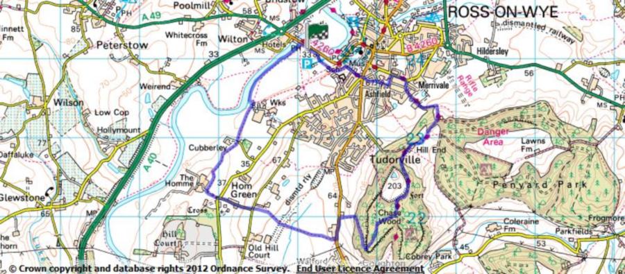
For an interactive version of this map click the image above or here
Route
This walk starts in Ross. If you approach Ross on the A40, at the roundabout where the A49 bisects the A40, go past the petrol station and over the Wye on the Wilton Bridge, towards the town centre. After a few hundred yards there is a car park on your right.
Walk along the car park until you have the skateboard park on your left. There’s a small bridge over a ditch. Continue following the public footpath in the same direction of travel you were going in.
Follow the path up a flight of wooden steps. At the top go forward for about 10 yards, until you reach a wooden post with footpath signs on, where you go right.
Go up for about 30 yards. When there is a metal barrier to slow down cycles, go left following the John Kyrle buggy route. After another 80 yards, turn right down an asphalted lane. Continue straight ahead into the residential road, and at the end cross the road towards the Prince of Wales pub. Crossover the main road at the lights just in front of the pub.
Turn left on the other side of the road, go along for a few yards and then turn immediately right. This takes you into a road where a public footpath bears right following a stone wall, and you want to go along this footpath.
Continue down on to Merrivale Lane, and you are now supposed to be following the Wye valley walk. However, at the bottom of the path where it meets Merrivale lane, there is a very misleading sign opposite you which looks as though the Wye Valley path goes to the right. It doesn’t, it goes to the left.
At the end of Merrivale lane go right, and then turn right again into Penyard Lane. Follow the lane, keeping to the right of the industrial units. At the end of the lane go through a metal kissing gate following the Wye Valley walk signs. Continue to follow the signs up hill.
You ascend through woodland and when you reach an open field turn right, keeping the wire fence close to your right, so that the mobile mast in the field is well to your left. At the top of the field turn right through a metal gate, and contine to follow the yellow arrows.
Eventually you will find yourself near the top of the hill, where the path skirts a clearing, which used to be an old fort. Just after this clearing, ignore the path which goes off on your right, but after about 20 yards the main path branches with the Wye Valley walk going downhill along the track. This is where you stop following the Wye Valley walk, and instead of going downhill bear right following the contours of the hill.
Go on for ¼ mile or so, where the track divides and you go left downhill. As you go down, the Forest of Dean is on your left hand side and after a while if you look back to your left shoulder you will see May hill, the highest point in the forest, with a distinctive tuft of trees on its dome.
Walk through redwoods and large puddingstones, and after some distance, cross straight over a forestry track.This will take you to a main road, where you go left.
Continue past the farm on your right, and cross over the road to the other side just after the farm. Follow the public footpath sign along the right hand side of a field, and continue following the path. Just after crossing over a section of the disused Ross-Monmouth railway track, you will see a hedge stretching out in front of you. The public footpath is just to the right of this hedge.
When we were walking the farmer had made life difficult by putting an electric fence on the edge of the field, squashing walkers into an unpleasant verge full of nettles. Our dog couldn’t understand why we were walking in such a ridiculous space, but soon found out when she was zapped as she went onto the clearer ground around the electric fence.
At the end of this field go over the stile, and walk diagonally right towards the farm, over another stile and then along the drive onto a road.
Turn left along the road, and then take the first turning to the right onto a smaller lane. Where this lane meets a larger asphalted road, cross over, go a few yards to the left and then follow the footpath sign into a driveway to a farm. Unfortunately at this point footpath signs disappear for a while. Just before you get to the buildings, turn right and walk between the hedge and the polytunnels (or their frames, depending on the time of year). After a hundred yards or so the path ( or more correctly when we were walking – muddy path ridged with tractor wheels) curves around to the left. After a few yards you will see a hedge to your right. Go right and walk on the near side of the hedge, so that it is on your left.
Continue walking, and soon the hedge is replaced with a wooden fence on your left hand side. Continue to follow this path, over a driveway, and onwards until you reach a signpost with two arms, both indicating the John Kyrle walk. Follow the left pointing arm towards the river, and when you reach the river turn right and follow the bank back towards Wilton Bridge. Take the steps up to the road, and then go right along the verge to the car park.
The walk
For years I’d been meaning to explore the woody tump which provides the backdrop for many picturesque photos of Ross on Wye, fronted by the river, and framing the elegant spire of St Mary’s church. A spire which is a landmark from miles around. I’d been rather put off the exploration by the neighbouring MoD areas, but on the bright spring day that we set off, we saw people calmly walking their dogs on a shooting range
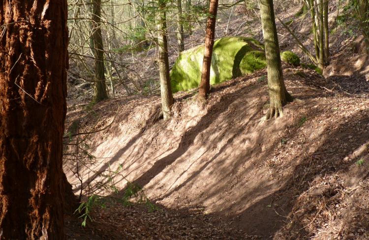
Once we had navigated the back streets of Ross we were into the woods proper. There’s clearly a lot of wildlife around. Ground had been disturbed by wild boar, there were several badger setts, and signs of deer eating the bark of redwood trees.
These redwood trees were growing throughout the woodland area. Their beautiful furry flaming trunks, scored by black furrows, were highlighted and delineated by the sharp cold spring sun.
The slightly Tolkein-esque atmosphere was accentuated by the strangely shaped pudding stone rocks. One by the side of the path looked like an enormous luminous green egg. Others were split by the path itself, so it felt as though we were walking through a grotto in the making.
On the way back we were met by a herd of sheep with odd neck ruffs, and long pallid faces – looking rather like bewigged and powdered French aristocrats.