
 Wye Walker
 This is one of the more iconic walks in the lower Wye valley. It takes a steep route upwards from Tintern, to the rock lectern where the devil is supposed to have tempted the monks of Tintern Abbey to turn to evil. The return route is north along Offa’s Dyke, with a descent into the pleasant valley in which Brockweir is situated (a less strenuous route to the Pulpit is described in a Walk A8).

SUMMARY
- Grade: Moderate-Difficult – the climb up to Offa’s Dyke has some steep stony sections, whilst the descent to Brockweir has steep and sometimes muddy bits. Fallen trees may need to be negotiated – and it’s better not to do this walk if high winds are forecast.
- Length:5 miles
- Key Features: Devil’s Pulpit, Tintern Abbey, Offa’s Dyke
- Refreshments: Brockweir shop and cafe; Brockweir Inn
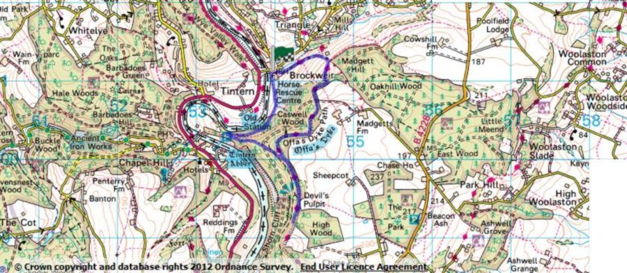
For an interactive version of this map click the image above or here
Route
 Park in Brockweir, and take a small road to the left of the Brockweir Inn (as you are facing it), and follow this around the Moravian church, over a stile and along the river bank. About 2/3 of the way along the field, the path goes left and upwards taking you to a stile.
After you have negotiated the stile turn right, and follow the old monks’ road. When you reach the section where the path goes over a railway tunnel (there is a low stone wall on the right hand side of the monks’road at this point), turn sharp left following the signed path to Offa’s Dyke. After a few yards the path forks, and you bear right towards Offa’s Dyke. Continue for about another 20 yards, and you will see a path going more steeply upwards, on your left. This path is indicated by a yellow marker. This is the original way to the Devil’s Pulpit, as you will see from the stone steps you’ll come across later on. Until recently the official signposts directed visitors along broader and more gradual paths, and so the old path has become somewhat neglected.
 You will eventually arrive at a forestry track, where you go right for about 5 yards, and then turn left at a path signposted to the Devil’s Pulpit (about a yard past this sign is mossy old stone signpost, and you can just about make out some of the letters).
After a few yards turn left again, and continue along this path until it crosses over Offa’s dyke. Turn right here and follow the Dyke (the earthen wall of the Dyke is on your left, and you are walking in the ‘ditch’ part of the structure). You will know when you’re coming close to the Devil’s Pulpit, because the path has been restored by the AONB.
After you have looked at the views from the Pulpit, you may want to carry on for ¼ mile or so because more views have been opened up along this section of the Dyke.
Retrace your steps, going straight ahead at the junction marking the path which you originally climbed up to the Dyke, following the signs to Brockweir and Saint Briavels.
 Keep straight along the Dyke ignoring paths which go off to either side, until you shortly after you reach a section where the path goes sharply to the right and over a stile. Once you are over the stile there are few ups and downs, and you continue along the Dyke until you see a newly renovated path on your left which will take you towards Brockweir.
As you emerge aim towards the stile on the lower right hand part of the field. Once you over this stile you go through a tunnel of trees, and come to a signpost. If you go straight on here (signed Offa’s Dyke and the Hudnalls) you will reach an asphalted road, and if you go uphill for ¼ mile you will find the Brockweir village shop on your left – a good place for a cup of tea and cake.
If you turn left (signed Offa’s Dyke, Brockweir and the Wye) it will take you to the bottom of Brockweir where you may have parked your car – and the pub at the bottom is a good place for a drink.
The walk
This is one of my favourite walks, particularly at a time when there are fewer people around. This area reeks of the past. On the section of Offa’s Dyke that you go along on this walk, you will see several ancient yew trees, and just off the Dyke before you descend to Brockweir is one of the oldest lime trees I’ve ever seen.

The medieval monks toiled along the monks’ road to farm their fields, and to pick apples for cider. About 300 years before them Offa made quite a statement with the Dyke which for many years marked the boundary between England and Wales, keeping the Welsh out of England. Now, in this section, it is the river which divides the two countries. Between the river and the Dyke are the houses of people in a no man’s land. Health Services, telephone connections, and the post all come from Wales. Taxes however are paid to Gloucestershire, and emergency services are – confused.

Back to the history. Well before Offa, this area was inhabited by stone age and iron age folk. The yew tree which you will see to the back of the pulpit, with its roots fantastically contorted through slabs of stone, has always has drawn me more strongly than the man made tales of a devil and some monks. It has been speculated that the stone had a role in pagan religious rituals, and that the section of Offa’s dyke which I’ve described may have been a ceremonial route. Who knows? Here though the past sometimes seems stronger than the present.