
 Wye Walker
 This walk is a lovely circuit from Llanidloes through farmland to the dam at the bottom of Llyn Clywedog reservoir, and then back over rolling hills.

SUMMARY
- Grade: Easy-moderate. Relatively easy walking with a few moderate ascents and descents
- Length: 11 miles
- Key Features: Old market hall in Llanidloes; remains of lead mines; Dam – Llyn Clywedog reservoir; panoramas over mid Welsh mountains.
- Refreshments: In Llanidloes
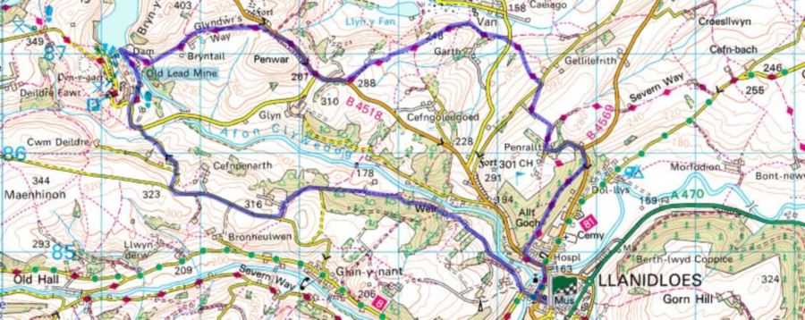
For an interactive version of this map click the image above or here
Route
 This walk begins at the old black and white market hall in Llanidloes. From there walk along Short Bridge Street, over the bridge, and turn right. Walk uphill for about 50 yards until a rough track goes off to the right, and follow this.
After about ½ mile this splits, and you keep to the right. A little further along the footpath has been diverted around a house, and you’re directed right down a grassy slope, over a bridge, and back up to the path you were on.
When you reach a more open space made by a field amongst the trees, turn left and continue to follow the path. From here continue following the footpath signs until you find yourself on an asphalted road.
When this reaches a sharp bend to the left you’ll find a bridle way signposted straight ahead of you, go through the metal gate to the bridleway. Walk along the line of the trees, and through another metal gate until you come to a rusty gate, which we went through – since the footpath itself seems to have been obscured at this point.
In a few yards the farm track meets a minor road where you turn right, and can enjoy some splendid views. After about a mile, on your right you will see a signpost to lower Tyn-fron cwm deildre, and you follow this through a metal gate, and keep to the right downhill. This will lead on to a minor road, which joins another asphalted road where you turn left.
 After about a mile turn right, down the road signposted to the lead mine. At the bottom of this road keep left and go on to the footpath. Cross the river and walk up past the remains of the 17th century Bryntail lead mine. After you have looked at this go through the gate and turn left uphill.
Towards the top you will find the path turns towards the left. At this point if you want a better view of the reservoir, you should make a small detour and go sharply left through a metal gate and choose a viewpoint. After admiring the view of the reswervoir, you will need to retrace your steps to the path that you were on.
The route back to Llandiloes follows the Glyndwr long distance path almost until the outskirts of the town. Where the Glyndwr trail crosses the Severn long distance path, take the latter back into the town.
The walk
This was one of those walks which we miscalculated. We set up camp in the middle of the afternoon and went into the town, popping into the tourist office on the way. They have an excellent folder of walks ( also see www.llanidloes.com/walk_llanidloes/index.html), one of which had seemed to be almost the same as the one which we had planned to try, and the distance indicated for this was 4 ½ miles.
Stupidly, we just accepted this and thought we would be back in time for supper at 7 o’clock with no problem. Instead, the walk turned out to be 11 miles and we didn’t have our supper until 10 o’clock.

When we set out the weather was close and humid, and all of the annoying insects in the world seemed to want to taste us. The temperature and wildlife got much better on the way back, but by then we were increasingly hungry and irritable – so I think this walk would be lovely on a pleasant spring or autumn day – and in the full knowledge that it does involve walking 11 miles!