
 Wye Walker
 This is a circular walk which begins near the holiday parks of Bronllys and Talgarth, but with glimpses of medieval history. The next stage is through farmland, until you climb steeply upwards for fantastic views of the Black Mountains. The way back is through woods and by a small river.

SUMMARY
- Grade: Easy-moderate. There is one steep grassy climb, and one steep descent through trees. One of the difficulties for us with this route was finding the footpaths – but hopefully the description will make that easier for you!
- Length: 7.2 miles
- Key Features: Bronllys Castle; Superb views at the top over the Wye valley in one direction and the Black mountains in the other.
- Refreshments: In Talgarth
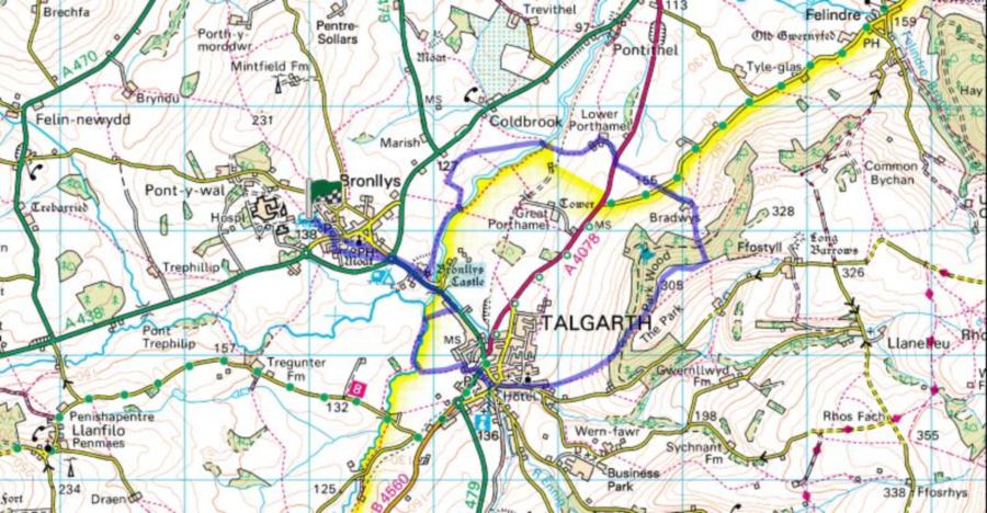
For an interactive version of this map click the image above or here
Route
This walk starts outside the Anchorage caravan park in Bronllys (mostly because we were camping there at the time). With your back to the caravan site go left, and then right down a street called Fosse way. At the end of the road is a wooden gate leading into a old ‘moated site’. Go across the site aiming for the far right hand side where there is a big oak tree. Go up to the left of the tree and turn sharp left along a (not very well used) footpath. After a short distance go right over a stile following the Talgarth walkabout sign. Continue down the left hand side of the field, and at the bottom turn left over another not very often used stile. Over a field, across another stile, and you find yourself emerging near a roundabout.
You want to be on the far side of the roundabout going in the direction marked A479 to Talgarth.
100 or so yards down the road on your left you’ll come across the entrance to Bronllys castle, which is well worth looking at. There aren’t any admission charges and it is open between 10.00 and 4.00.
About 10 yards down the road from the castle on your left there is a public footpath sign which you follow. Continue to follow the yellow arrow with a black footprint in the middle. This route takes you along the river, you then turn leftwards, and eventually find yourself walking along the upper edge of a very very large field. At this  point the signs seem to disappear, so at the end of the field turn right again, walking down along the edge of the field. At a metal gate, look over and you will see a footbridge over the river –which is where you want to be – so head towards it.
After the footbridge take the path which goes diagonally left from the bridge. You come to another footbridge which you go over. After this head diagonally right.
Go through a farm gate, over the disused railway, and through another gate, turn left and follow the path around the field. Go through a gate with a white house on your left. and carry on down a lane. At the end of this you come to the main road which you cross over, going right on the pavement for a few yards, and then turn left where a footpath is signposted.
Go up the left hand side of the field, through a metal gate, across a minor road, and opposite and slightly to your left is a driveway to Bradwys farm. Follow the drive towards the farm. At this point, things become quite tricky, since the farmer clearly does not like walkers. Turn left in front of the farm buildings, until you come to a second barn, where you go right over a gate. Walk diagonally right, make your way through a little orchard, climb the lowest point in the fence yo u can find, go straight through a small field, through some hedging trees, and you will find yourself in the bottom left corner of a steep uphill field. If you look up and to the right, you will see the very welcome sight of a stile and clear signposting – head towards these. There are fantastic views back over the Wye valley at this point, and if you look back over the farmhouse at about one-o’clock you’ll see Maesllwch ‘mock’ castle in the distance.
Unfortunately, once you’re over the stile, and despite the nice signposting, you’ll find there’s a short stretch of nettles and brambles, which you just have to grit your teeth and get through. It’s only about 30 yards long, and then you’ll find yourself on a grassy track. Follow the signs left, and then after about 30 yards, follow the sign right.
At the top you go over a stile, and if you continue forwards for 20 yards you get the most fantastic views over the near peaks of the Black mountains.
Head right to  a stile, and over the fence, following the yellow arrow. Carry on around the field, until you reach for the next stile (where Talgarth walkabout signs also re-emerge), and continue straight ahead. Continue to follow the Talgarth walkabout signs, and you’ll find yourself going over a stile into some woods, and taking a path which goes more or less straight downhill. The path continues down, it does cross over some other paths, but you take the direct downhill route.
Eventually you go down a lane into Talgarth, and then turn right and follow the slightly bigger road as it veers left. Cross over the main road, and take the road between the NatWest and the Co-op. On your left there is a little path that goes towards the river, and you then walk along the left bank of the river until you get to the A479, which you cross over and follow the footpath signs straight on.
Go right in front of the sports pavilion, carry along the road for about 50 yards, and then turn left through a metal kissing gate, following the sign for the Talgarth walkabout. Continue straight over the next few fields, until you come to a bridge which goes over the river, and then turn sharp right and walk around the edge of the field.
Continue until you come to a big concrete slab going over the river, use this as a bridge and cross back across the river. Go along the right side of the field. At the end ofthe field go through the wooden gate on your right, and you will find yourself in a sort of driveway, and you will see a little picket gate with a notice saying “shut the gates behind you”. Go through this, and another similar picket gate, and then cross over the main road, turn left and stay on the pavement until you reach the roundabout which you traversed earlier. Go straight over into Bronllys, take the left hand branch of the one way street, then left again and you’ll find the campsite on your right.
The walk
This was a strange walk. Right at the beginning there were reminders that there were some interesting medieval settlements in this area, and some truly immense old oak trees just beyond Bronllys castle. However, the paths were not easy to follow, and a sense of frustration began to set in. This reached a climax at Bradwys farm, where I found myself trying to think of reasons why anybody would do this walk. The main one which occurred to me was a sense of fulfilment walkers may or may not get by helping to keep footpaths open. The worst part was emerging from the farm, seeing a beautiful stile and signpost, and then having to thrash through the nettles and brambles again- and not knowing how long they would go on for. At least anyone using the description above, has the comfort of knowing that in fact it’s only about 30 yards.

However, when we got to the top and saw the autumn sun on the bronze bracken of the mountains, it was all worth it! Really beautiful views, and some slightly mad multicoloured sheep (well -lots of shades of brown, black, and cream) who trailed behind us, stopping to stamp their feet when we stopped to look at them. Maybe the farmers had trained them to run walkers off the land?
