
 Wye Walker
 Coppetts Hill and the associated ridge along to the Wye is effectively a peninsula almost enclosed by one of the more extravagant meanders of the river Wye, and one which can be seen easily from the top of Symonds Yat. This walk starts near Goodrich and follows the side of the ridge which goes down the middle of the peninsula – with lovely views, and then the walk goes downwards until you emerge opposite an array of vertical cliffs which include Symonds Yat rock. Instead of cutting back to your starting point after the first meander, you can extend this walk by about 1½ mile and follow the river along the next meander to finish by climbing a short steep slope to get back into Goodrich.

SUMMARY
- Grade: Moderate – mostly straighforward, but the descent to the river can be muddy and slippery
- Length:6.5 miles
- Key Features: Welsh Bicknor Church; old railway bridge over river; views over Goodrich, Herefordshire hills, and of Symonds Yat Rock, the Coldwell rocks and Ship rock
- Refreshments: There is a tea shop at Goodrich castle – but it closes at 4.00. Or you could drive to the top of Symonds Yat and get some refreshments there.
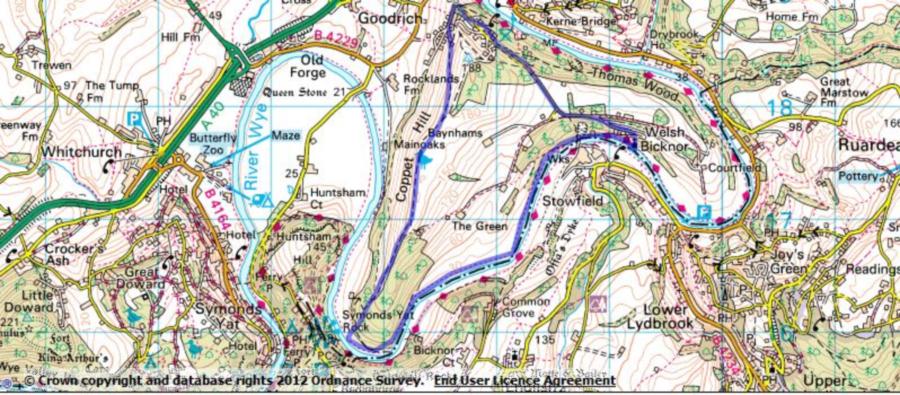
For an interactive version of this map click the image above or here
Route
 Go into Goodrich on the B4229, and in the middle of the village take a very sharp right onto a C road which takes you over the B road. Not too far out of Goodrich you will find a largish grass triangle on your right, where there is usually a parking space available.
You will see a sign for Coppetts Hill Common. As you face the sign, take the road to your right. Go past ‘Hill Brow’ and ‘Wren cottage’, and about 50 yards from the junction there is a fork, where you bear left along the asphalted track.
Go past a house called ‘Cloud Nine’, and continue along the lane. After about 15 yards, go left again at a garage and a white cottage. The path then takes you Coppett Hill Common.
 Towards the top of the rise the track bends round to the right, and a yellow arrow indicates that this is part of a circular walk. Eventually you will go from more open scenery into a steady downhill path through the trees. At the bottom is a stile which takes you into a field bordering the river. Straight ahead is the cliff which is a nesting place for peregrine falcons – and the telescopes at the top of Symonds Yat are trained onto the nest at the right time of year.The cliff is part of the Coldwell rocks, and if you look to the right of this you will see another vertical cliff face which is the Symonds Yat rock. This doesn’t look particularly big, until you notice that the tiny dots on top are people.
 Walk down to the riverbank, turn left and keep following the yellow arrows along the river. After some time you will notice that on the opposite bank there is a large disused factory, Lydbrook cable works, which supplied most of the telegraph cable in World War Two. It closed in 1965. At around this point you go over a stile and enter a more narrow wooded area. The next encounter will be with an old viaduct which connected the rail line from Cinderford to the Ross-Monmouth railway. The viaduct was built in 1874 and last used in 1951.There is still a pedestrian route across the viaduct, and it’s well worth while having a look at this. When you come back from having a look, you might want to venture a little further along where there is an old railway tunnel.
Continue walking along the river bank, until you see the pretty church at Welsh Bicknor coming up on your left. After you have looked at the church you take the drive which goes in front of a large building, which is now used as a youth hostel. Continue to follow the drive uphill, and eventually you find yourself going through some rather elegant parkland. This leads on to the tarmac road which lead to back to your car – as you go down this keep your eyes open and on the right there are some good views of Goodrich Castle and Kerne bridge (the road bridge over the river).

The walk
As you walk along the side of the central ridge there are fantastic views over Goodrich – dominated by St Giles church, the hills of Herefordshire, and occasional views directly ahead of the Symonds Yat rock. You can also see clearly how the river Wye meanders in the Herefordshire plain (and how popular it is with canoeists!). You may notice a small metal road bridge over the river – and this always feels very flimsy when you drive over it – as you may discover at some point in your visit.

We did this walk on a day in late autumn, with the hedges rich in hawthorn berries, rosehips, old man’s beard, sloes, blackberries, crab apples and even pears. We also spotted a solitary autumn crocus. There were deer in abundance, and also pheasants and buzzards. Close to the church at Welsh Bicknor, safely ensconced about 10 yards from the bank on a rocky outcrop there were two swans with a bumptious brood of five or six adolescent cygnets. Poor parents.

We came across some other poor parents as well. As you walk along the river bank towards Welsh Bicknor, you’ll come across a memorial on your left, for a 16 year old boy who was drowned in the river in 1804. The inscription is long, but one section reads “this monument is here erected to warn parents and others to be careful how they trust the deceitful stream and particularly to exhort them to learn and observe the directions of the humane society for the recovery of persons apparently drowned”.
