
 Wye Walker
 There is a very confusing maze of lanes and footpaths on the steep slope between Brockweir and St Briavels. This walk describes the way from the pub at Brockweir, up almost to the top of the hill, a descent through the woodlands of the Hudnalls , and then back to Brockweir along the river.

SUMMARY
- Grade: Moderate – steep and sometimes slippery, with the first half uphill and a downhill return journey
- Length:4.3 miles
- Key Features: Hudnall’s Common – a national nature reserve and SSSI with a rich diversity of species -both local and rare. View of the Wye Valley, and a stroll along the banks of the river.
- Refreshments: Brockweir Village Shop, The Crown or the George at St Briavels.
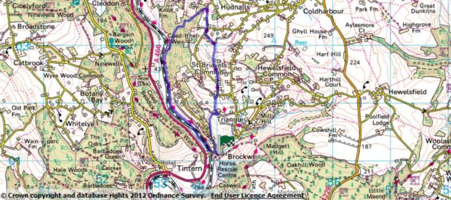
For an interactive version of this map click the image above or here
Route
Park in Brockweir, and start the walk from the Brockweir Inn.
 Take the road opposite the pub (the road is called Underhill – but doesn’t have a sign) and walk uphill until you come to a ‘restricted byway’ on your right, just before Orchard Cottage. Walk uphill along the path, going first of all through a wooded section before you come to are more open stretch with fields on either side.
Where the footpath meets a lane you need to turn right for a few yards and then sharp left at a double track ‘restricted byway’.
 After about 20 yards there is a T junction on to another footpath, where you go left up hill. At the top of this path turn right onto the small asphalted road and continue along for about 30 yards, until you reach a slightly larger asphalted road and here you bear left by a small house called ‘The Paddocks’.
After you’ve gone up hill for about 200 yards, go right up a ‘restricted byway’ with the ‘Offa’s Dyke’ waymark. After 30 yards or so the road ends but changes into a track which goes to the left of ‘Hilgay cottage’. You will pass a wind turbine on your left. When you get to the top of the section continue to follow the Offa’s Dyke path along a left hand fork. At the top of this stretch you will see a mobile phone mast straight in front of you, and here you take to the left hand turn along a farm track – still following the Offa’s Dyke waymark.
After a few yards or so turn right through a metal kissing gate, and go across the field and through another metal kissing gate. Follow the side of the field downhill, until you come across a third metal kissing gate. Go through this and turn right on the asphalted road, until you come to a ‘restricted byway’ sign on your left signed with the Offa’s Dyke waymark, and also signposted to ‘Oak Cottage’.
You take this path past Oak cottage and downhill for about a quarter of a mile, until you come to a section where a farm track curves around, and you need to head left (when we did this walk the Offa’s Dyke sign was missing at this point). Pass a house called ‘Meg’s Folly’, into the wooded area called the Hudnalls.
 Ignore the public footpath sign on your left just after ‘Meg’s Folly’, and keep to the main track. You will pass a point where the trees have been taken down for electric cables, and looking right you can see across to Llandogo. A few yards on from this on your right you will see a memorial to Tony Bomford – a wildlife photographer and filmmaker who lived locally, and died in 2001.
Keep on the main track, and don’t be diverted by smaller footpaths which join this at various places, including one which goes off to the right and has a proper public footpath sign on it.
You’ll come across an information point which describes some of the vegetation characteristic of the Hudnalls, and below this information point the main track bends around towards the right, and you continue along it until you come to an isolated cottage.
When you get to this cottage turn sharp left in a line away from the gate of the cottage, and you will find that the path becomes much smaller, but is now definitely heading back towards Brockweir. At the bottom, go through the metal kissing gate, and turn left along the river – until you arrive back in Brockweir.
The walk

We did this walk in a brief thaw after a prolonged period of really cold weather, when it had been about -10 degrees at night-time and had not risen above freezing during the day. As a result of this there was a layer of mist at the bottom of the valley throughout the walk, looking like the ghost of an immense python, winding its way to the sea.

There were some amazing views , although these were not easy to spot between the trees. As you get higher up (just past the mobile phone mast) on a clear day you can see the Severn Bridges, with smoke rising from the factory chimneys of Avonmouth and Portishead. Higher still, just after you’ve gone through the first metal kissing gate, you’ll see the other side of the Wye valley spread out before you. The section you can see is described in Walk A3. On the ‘Oak cottage’ section of the Offa’s Dyke path, and off to the right, you can see views across to St Briavels.
Given the wintry feel of the day, it was surprising to see so many signs that plants were already preparing for next spring. There were embryonic catkins on the hazel trees, and the leaves of bluebells were already positioning themselves to make the most of the spring light.
This part of the Wye Valley is characterised by small fields, and a complex network of lanes and paths. The Hudnalls is particularly fascinating – an area of common land, where trees used to be coppiced for firewood. This doesn’t happen any more, so in some places there are bizarre multi-stemmed trees rooted in stone outcrops and with their main trunks daily defying gravity. In the eighteenth century there was a small industry here, making millstones. The hastily built cottages of the workers are now tumbledown, and parts of millstones can still be found. Just after the memorial to Tony Bomford you will pass what at first glance looks like a moss covered stone wall. It is only as you go on a little further and look back, the structure of a cottage becomes more apparent. It is difficult to describe the feeling of this area, but it is – different – maybe because it is so clear that man’s efforts are puny in the face of the time and persistence nature has at her disposal. The only habitation on the Hudnalls is a locked up cottage, which could easily be the setting for a modern day Hansel and Gretel story.

As I mentioned earlier we had just had a prolonged spell of very cold weather. Towards the end of the daylight we were going down through the last section of the Hudnalls, and we could see the river on our right. The water itself was very still and looked almost black, but on either side there was startling white bands. When we got close enough to have a proper look, we realized that the weather must have been so cold that when the tide came in the water at the edges froze. The tide then went down, leaving the edges remained frozen. The next time the tide came in the whole process had been repeated, until there were strata ( see photo) of thick ice on either side of the river. So, whilst we had only had an inch or so of snow, the banks of the river looked as though there were 10 foot snowdrifts. With a slight thaw, slabs of ice were dropping into the river to make ice floes – the first time we had ever seen anything like this on the Wye.

Walking back along the river bank, we were in the mist we had been looking at from above all day. There is a very pretty boathouse, which belongs to Brockweir house, and walking towards it was almost as though we were viewing it through tracing paper, seeing just a black and grey and white image, apart from flashes of deep reddy-orange. Much to my surprise, these flashes turned out to be the stems of Japanese Knotweed. Maybe because it is such an indestructible bully, I had thought it was ugly at all times of the year – but it clearly has some redeeming features.
